|
| About Us |
| What's New |
| Preparedness |
| Drills/Exercises |
| Training |
| Operations (SOP) |
| Frequencies |
| Links |
| Archive |
| Site Index |
| Membership |
| Projects |
| Home |
| City of Cupertino |
| Contact Us |

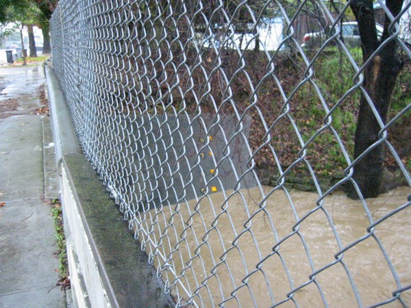
Creek Watch and
Winter Preparedness
An outcome of the Cupertino (100) Critical Facilities work started in 2003, CARES recognizes that we may be called out to check on the state of various creeks within the City. This Creek Watch covers the following areas:
- Calabazas Creek at Saratoga-Sunnyvale Road
- Calabazas Creek at Bollinger Road
- Calabazas Creek at Miller Avenue
- Calabazas Creek at Stevens Creek Blvd
- Calabazas Creek at North Tantau Avenue
- Regnart Creek at Regnart Road and Lindy Lane
- Regnart Creek at Festival Drive and November Drive
General Notes:
- SAFETY FIRST! If you think you are too close to the creek, then you are. DO NOT put yourself in any danger to make an observation. All observation points described below should be safe.
- DO NOT respond without a Buddy.
- Make sure your vehicle is safety parked prior to exiting. Use your emergency flashers to help illuminate your vehicle.
- All creek observations should be made at the inlet side of all underground waterway.
- If responding, wear raingear and bring a strong flashlight.
- Report your movements (leaving, arriving, in transit, etc) to the Net Control Station or EOC.
- Report your departure from and return to your home to the Net Control Station or EOC.
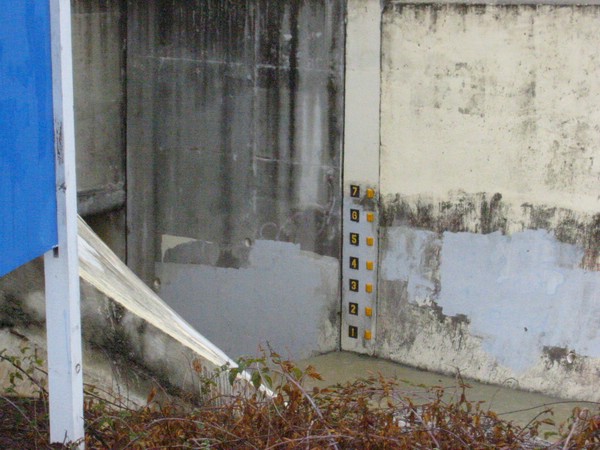
Calabazas Creek at Saratoga-Sunnyvale
| Location | Saratoga-Sunnyvale Road (west side), south of Prospect Avenue |
| Park | Parking lot next to the Caldwell Banker building |
| Notes | Marker "7" aligns with the top of the
water enclosure.
While this creek is officially in Saratoga, this location is a good indicator for potential problems occurring downstream in Cupertino. The creek enters an underground waterway here and emerges on the north side of Prospect Avenue, east of Saratoga-Sunnyvale Road, behind the Shell Station. |
| Observations | Stay on the parking lot. The dirt bank shows signs of erosion. However, the height of the water entering the underground waterway can safely be observed from the parking lot. |
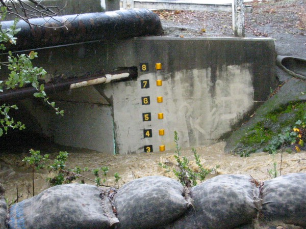

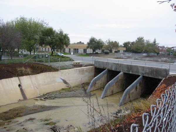
Calabazas Creek at Bollinger
| Location | Bollinger Road between Miller Avenue and Blaney Avenue |
| Park | South side of Bollinger, immediately east of the Creek in the Valley Water District driveway. |
| Notes | Water entering the
underground waterway immediately drops several feet. Marker "8" aligns with the top of the
water enclosure.
This creek last overflowed its banks during the 16-Dec-2002 rain storm. |
| Observations | The level markers are on the east bank. Proceed to the west side of the creek to see the level markers. |
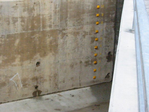
Calabazas Creek at Miller
| Location | Miller Avenue, south of Stevens Creek Blvd, next to the Fontainebleau Apartments. |
| Park | East side of Miller, south of the creek. |
| Notes | Marker "9" aligns with the top of the water enclosure. Water observed at Marker "10" will mean the creek will most likely breech its banks. |
| Observations | Observe the level on the south side of the creek against the fence, west side of Miller. |
Click on each picture for a larger view
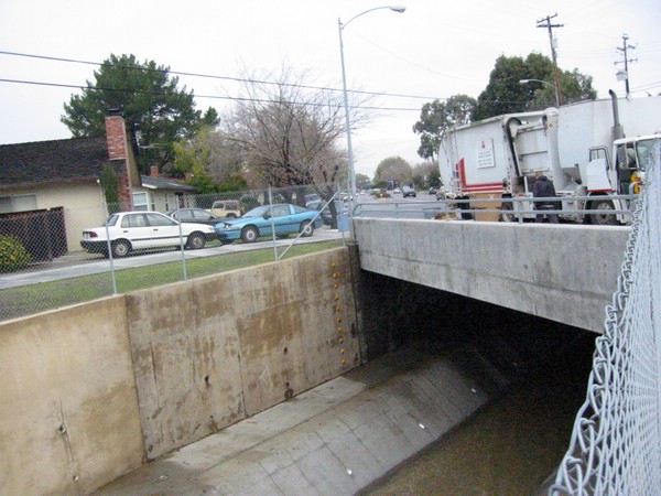
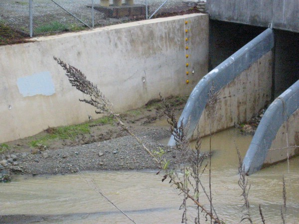
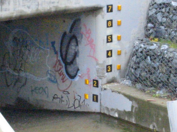
Calabazas Creek at Stevens Creek
| Location | Stevens Creek Blvd between Miller Avenue and Johnson Avenue |
| Park | Bank of America Parking lot or driveway. |
| Notes | Marker "6" aligns with the top of the
water enclosure.
East side of the creek is private property. Water entering at this point travels through an underground waterway and emerges on the North side of Valco Parkway between 2 old Tandem buildings. The creek then enters another underground waterway and travels under I-280. |
| Observations | Best observation point is on the west side of the creek up against the fence facing the Stevens Creek Blvd. |

Click on each picture for a larger view
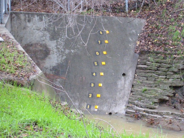
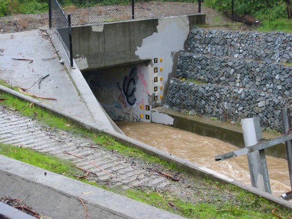
Calabazas Creek at Tantau
| Location | Stevens Creek Blvd on N. Tantau between Stevens Creek and Pruneridge |
| Park | West side of N. Tantau, parking lot south of the creek. |
| Notes | Marker "10" is just
above the top of the
water enclosure.
This is the last observation point for Calabazas Creek in Cupertino. From here, it flows into Santa Clara. |
| Observations | Best observation point is on the south side of the creek by the fence. |

Click on each picture for a larger view
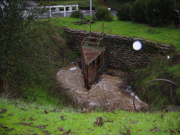
Regnart Creek at Lindy
| Location | Regnart Road and Lindy Lane |
| Park | West side of Regnart Road |
| Notes | Regnart Creek enters an
underground waterway here. A debris guard is in front of the entrance.
Based on the mud on the street observed on 17-Dec-2002, it appears that this creek overflowed during the 16-Dec-2002 rains due to heavy debris buildup. This location is maintained by the City of Cupertino. Contact the Department of Public Works for problems at this site. |
| Observations | From the road. Note any blockage and overflow of the creek onto the road. |

Click on each picture for a larger view
Regnart Creek at November
| Location | Festival Dr and November Drive, closest major cross street: Orogrande and Stelling by the Stelling / RT-85 overpass. |
| Park | West side of November Dr, across from the creek. |
| Notes | Regnart Creek enters an
underground waterway here and flows below RT-85. A debris fence
is located In front of
the waterway entrance.
Santa Clara Valley crews were removing a significant amount of debris here on 17-Dec-2002. |
| Observations | From the road next to the creek. |
Click on the picture for a larger
view
updated: December 15, 2004